The PoleOS™ Company


IKE at a glance
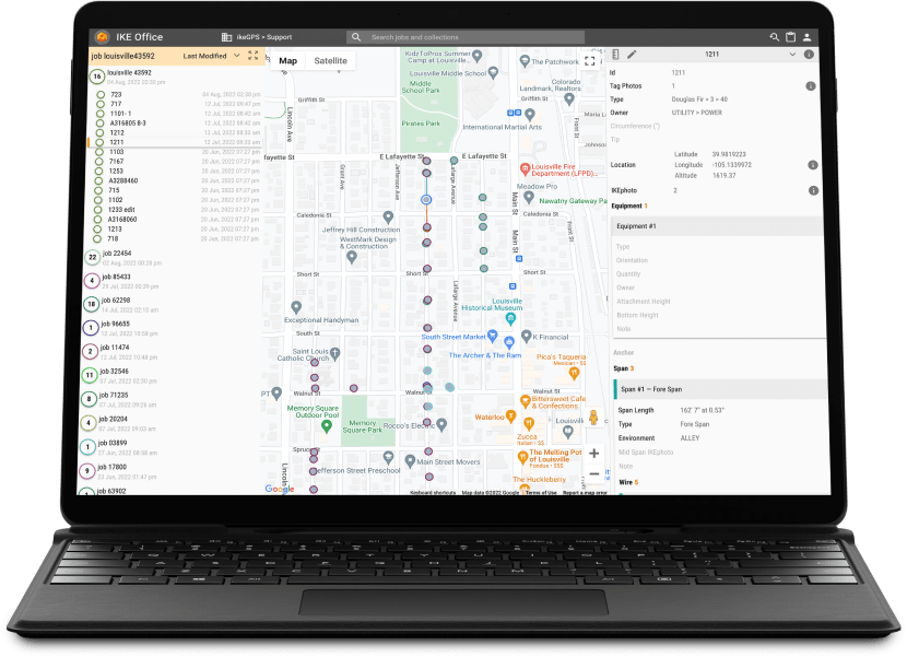
Collect in the field
Your team collects in the field using the IKE and IKE+ Devices
Measure in the office
Your analysts measure and manage in the IKE Office Pro cloud
Export and automate
Export and automate into whatever system or format you need
A solution built for poles

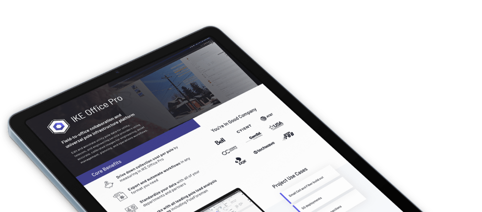
IKE Office Pro
Purpose-built cloud software to measure and manage poles quickly, then export them to your native systems.
See Software Capabilties
The IKE Device
The field hardened device that combines GPS, Laser rangefinder, calibrated image capability, and a user friendly app.
Learn About the IKE DeviceDrive the outcomes you need without pole data slowing you down.
Safely speed up field data collection
Capture field data fast while keeping fielders safe with the most advanced pole survey technology on the market.
Get to revenue faster with digitized data
Get permits and construct faster with high-quality data standardized and automated for your workflows.
Increase data quality and reduce revisits
Custom forms and multiple validation points means you get high quality data in one trip to the pole.
Get real time metrics with project-specific dashboards
See the metrics of a collection and the efficiency of the collector with data uploaded from the field.
Simplify your
pole load analysis
Direct integration with PoleForeman (an IKE Structural product), O-Calc Pro, SpidaCalc, and PLS CADD makes pole loading as simple as point and click.
Integration with IKE software and services
Records from IKE Office Pro can be used for PLA in PoleForeman, AI in IKE Insight, or we can do the work for you with IKE Analyze.
Get the IKE Office Pro Datasheet
DownloadHelping clients find success
Hundreds of companies nationwide combine IKE Field Tools and IKE Office Pro to complete projects.
Customer Success Stories
3X
reduction in recollects
30%
reduction in recollects
TWiG Technologies put people first and used IKE to audit 200k poles for a major US utility.
Read the Case Study
90+
Devices
4
Critical New IKE Office Features
50
years of experience
1
day to learn IKE
Horrocks Engineers has replaced the traditional way of collecting pole data with IKE to make MRE field data collection faster than ever before.
Read the Case StudyWhat does IKE Office Pro do?
Measure and annotate poles, spans, equipment
Create a clear picture of your network using data from the IKE Device to annotate heights of attachment, identify equipment, and measure spans and anchors.
Manage your data via cloud connected software
Build, manage, and share your projects with your team online and in one location.
Map your poles
Get an overview of your projects and collections with a detailed interactive map.
Export data in dozens of ways
Robust exports allow your data can go where you need it -- IKE Report, KML, EXCEL, JSON, raw and annotated images, and more.
Measure every part of a pole.
IKE Office Pro allows you to measure the most important data points on a pole and verify all of the data coming from the field quickly.
-
Location
Measure the location of a pole with up to 4 centimeter accuracy.
-
Pole Height
Identify and quality check height, class, type and more.
-
Span Length
Measure a backspan once and copy it to the next pole as a forespan.
-
Height of Attachment
Measure heights and classify all of the equipment on the pole.
-
Guy Wires
Measure anchor lead length, guy attachment height, and guy length.


Cloud software capabilities
Purpose-built cloud software to measure and manage poles quickly, then export them to your native systems.
-
Build custom forms
Create and edit forms defined by your project needs
-
Measure and annotate IKE Records
Build IKE Records and QC data from a single screen.
-
Interactive maps
Get the big picture of your project.
-
Exports
IKE Report, KML, EXCEL, JSON, raw and marked up images.
-
Prepopulated fielding routes and work plans
Load existing data onto the IKE Device and update it from the field with data roundtrip.
-
Pole loading analysis integration
Integrates with PoleForeman, SpidaCALC, O-Calc Pro, and PLS CADD


Track project metrics in real-time with IKE Dashboards
Custom-built dashboards can create intelligence out of any piece of data from IKE to allow you to make better decisions and manage teams like never before.
-
Project Specific Executive Insights
Dashboards can show any data available in IKE Office for project specific customization that provides executive level insights into all aspects of the project on a near real-time basis.
-
Project Status Reports
Once a pole is uploaded from the field, it is represented in the dashboard so you can track project status and metrics to an incredible level of detail.
-
Individual Fielder Metrics
The project manager can see exactly how many poles their team was able to collect on any given day of the project.
-
Hour by hour productivity rates
Easily identify and provide coaching for anyone falling behind.


IKE Office Pro Features
Our feature list continues to grow. Stay tuned to this page or subscribe to our product update announcements to stay up to date with our growing capabilities of IKE Office Pro.
Configuration
| Admin assigned roles:Admin, User |

|

|
| Admin assigned advanced roles:Downloader, Viewer, Editor, and Data Admin |
|
|
| User Management Options:Add, Promote, and Delete Users |
|
|
| Units Options:Imperial and Metric |
|
|
| Form Management:Create, Rename, Delete and Share (across departments) forms |
|
|
| Basic Form Fields:Text, Date, Select List, Yes or No, Nested List, Create Subforms, Clone Forms |
|
|
| Advanced Form Fields:Secondary Label, Admin-Only, Required Fields, Hide in Field (on IKE Device), and Vertical Separation |
|
|
| Build forms from PLA equipment catalogs:PoleForeman, O-Calc, SPIDACalc | (with annual integration cost) |
|
| Update existing collection forms to newest version |
|
|
| Workflow status tracking |
|
|
| Import CSV data |
|
|
| Auto-label height annotations with any form field |
|
Project Management
| Organizational wide search |
|
|
| Search for Secondary Label Fields, Collection Titles, and Job Names in both map search and organizational wide search pages |
|
|
| View and sort Collections by:“collected at,” “collected by,” “title,” and “last modified” |
|
|
| View and sort Collections by:“status” and “assigned to” |
|
|
| Bulk update the “status” of Collections |
|
|
| Move Collections and Jobs between departments |
|
|
| Move Collections between Jobs |
|
|
| Delete Collections (by user role) |
|
|
| Assign Collections and Jobs to users |
|
|
| Admin-Only editable fields |
|
|
| Upload and attach files to a collection:(supported file types: JPG, PNG, PDF, DOCX, etc.) | (per request) | |
| Customized configured dashboard for project management | (per request) | |
| Flexibly create a selection of poles for export |
|
|
| Hide photos for exports |
|
As-Built (Pole Locations and Spans)
| Street view manual location |
|
|
| Visibile location accuracy |
|
|
| Address geocoding | (per request) | |
| Manually edit location fields |
|
|
| Manually edit height fields without annotating |
|
|
| Manually edit anchors and drop-spans |
|
|
| See spans and anchors on the map |
|
|
| Relocate Collections over a map in “Map Mode” |
|
|
| View location accuracy for all Collections based on color in “Map Mode” |
|
|
| Snap spans to poles for an entire job at once in “Map Mode” |
|
|
| Relocate spans and anchors over a map in “Map Mode” |
|
|
| Collection Linking:Link poles to obtain span measurements on a map |
|
|
| Link poles, spans, and data from a select list based upon proximity (PLA form only) |
|
|
| See on map where an IKE Photo was captured |
|
|
| See span direction arrow on photo while clicking in a span subform |
|
|
| Color coded spans |
|
As-Built (Heights of Attachment)
| Zoom window |
|
|
| Measure heights directly into a form |
|
|
| Copy heights when copying a subform |
|
|
| See compass orientation (IKE Photo) |
|
|
| See distance to a pole (IKE Photo) |
|
|
| Exposure compensation (IKE Photo) |
|
|
| Measure heights above ground (IKE Photo) |
|
|
| Measure pole diameter (IKE Photo) |
|
|
| Set base offset (IKE Photo) |
|
|
| Measure vertical separation (IKE Photo) |
|
As-Built (Equipment)
| Photo upload from your computer |
|
|
| Pole Tag Photos |
|
|
| Add, Edit, and Delete equipment |
|
|
| Fill form(s) from preconfigured select lists |
|
|
| Edit field observations |
|
|
| Measure wire diameter from an IKE Photo |
|
|
| Set print area of an image |
|
|
| Special search bar for wire or equipment when selecting from a list |
|
Pole Load Analysis (PLA)
| Export directly to PLA software:PoleForeman, O-Calc, and SPIDACalc |
|
|
| Load PLA results (PDF, PPLX, XML) into IKE Office Pro | (one time request) |
Make Ready Engineering (MRE)
| Standard files download options:IKE Report (PDF), KML, EXCEL, JSON, and raw annotated images |
|
|
| KML extended vector information:Spans and wires |
|
|
| Shortened IKE Report |
|
|
| Composite Photo Report PDF (annotated IKE Photos only) |
|
|
| Photo Report PDF (only IKE Photos and tag photos) |
|
|
| Time and date stamped photos |
|
|
| Download previously uploaded PLA files | (per request) | |
| Raw thumbnails in reports |
|
|
| Custom Outputs:Populate existing customer forms (via IKE Solution Engineering) | (one time cost) |
|
| Access to your data through the IKE Office API |
|
|
| Export altitudes in NAVD88 (excel) | (per request, per department) | |
| Duplicate a pole for independent MRE scenario |
|
Connect to the Field (IKE and IKE+)
| Assign work to an IKE Device user |
|
|
| View and download collections or jobs that are assigned to you |
|
|
| Access Data Round Trip (sync data to and from the data collector) |
|
|
| Option to download or skip collections with photos |
|
|
| Required fields indicator (as configured in the form) |
|
|
| Collect at least 1 IKE Photo indicator |
|
|
| Clone Collection (includes all subforms) |
|
|
| Copy subforms or collections |
|
|
| Measure midspan heights from a safe distance |
|
|
| Option to review photos after capture |
|
|