The PoleOS™ Company



Your field-to-finish platform for utility pole data
Collect data in the field with the IKE Device. Send it to IKE Office Pro, where it becomes a structured, annotated, ready-to-use record for engineering, GIS, or permitting. Purpose-built for utilities, telecoms, and engineering firms.


















From field to finish in four steps
A single connected workflow — capture in the field, verify in the office, and deliver to the systems you already use.
Collect
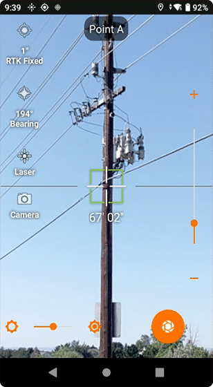
Capture utility pole information and photos using the IKE Device, then securely upload data to the cloud platform.

Annotate
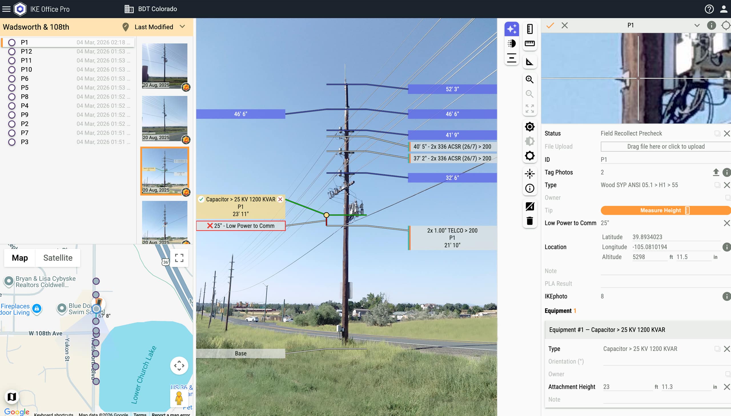
Verify field data and measure attachment heights, equipment, spans, and separation from calibrated photos.
Report
Leverage custom dashboards to track project metrics and team performance across every job.
Deliver
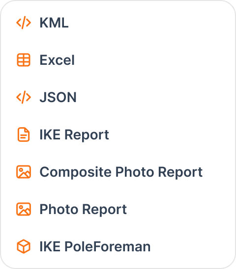
Export pole records with one click to industry-leading PLA software and your other systems — in your preferred format.
Collect, annotate, report, deliver — faster
Manage field data collection, collaborate across teams, automate pole data analysis, and export standardized records directly to your existing workflows.

One technician, fewer revisits
Collect complete pole data in one visit with a single field technician.
- Reduce labor costs by up to 50% by avoiding two-person crews
- Workflow forms with required fields mean accurate data in one trip


Capture from a safe distance
Keep crews away from environmental hazards and contact with energized equipment.
- Avoid hot sticks and potential contact with live wires
- Reduce exposure to busy roads, dense vegetation, and animal encounters



Built for collaboration
From the field to the final deliverable, your data gets where you need it faster.
- PolePilot, our sophisticated image recognition engine, completes annotations 30% faster
- Flexible exports and integrations with leading systems
- Field, office, and third parties can all access up-to-date data, eliminating version confusion and communication delays


Trusted by respected grid service providers

INTEC accelerates utility pole modeling and engineering analysis
“IKE Office Pro saves us considerable time on the engineering side. The vertical separation tool is extremely helpful in ensuring compliance with utility and NESC standards.”


Toth & Associates speeds up pole data collection and accuracy
“We needed a single device that removed four or five devices from our fielders’ hands and the software to bring all of our field data together.”


Wōden transforms broadband infrastructure projects with IKE
“The efficiencies have been noteworthy. We’ve cut field time by 30–40%, and office processing time is nearly half of what it used to be, thanks to the elimination of manual re-keying and data validation.”

Get your data where you need it

Robust integrations & exports
GIS
- ESRI ArcGIS
- QGIS
- FME
- Google Earth
Pole Loading Analysis
- IKE PoleForeman
- SPIDAcalc
- O-Calc Pro
- QuickPole (Sonideft)
- Power Line Systems
Design / CAD
- Autodesk
- IQGEO
- SBS
- DDS
- SSP Innovations
Joint-use
- NUINS
- Alden
- Varrasset
- SSP SPANS
Exports
- KML
- Excel
- JSON
- Photo Reports
- IKE PoleForeman
More integration possibilities via API — no add-on fees.
Solution highlights
IKE Device
Capture field data with the IKE handheld device and sync it directly into your IKE Office Pro workflow.
Learn more about IKE DeviceVertical Separation Tool
Measure the separation between two attachments on a pole — with red/green indicators — ideal for supporting make-ready work.
Collection Linking Tool
Create a vector between any two poles and get the length and bearing associated with that span.
Map-Based Review Mode
Interactive maps help you get the big picture on your collections or hone in on specific areas.


Your questions answered
Can’t find the answer you’re looking for? Please chat with our friendly team.
Utility pole data management is the process of collecting, organizing, and analyzing information about poles and their attachments. This often includes specifications, equipment details, attachment heights, and GPS locations. It enables utilities and telecom companies to make informed decisions about maintenance, joint use, fiber deployments, and safety compliance.
Data needed is project specific and depends on how it is going to be used downstream. Typical requirements include pole specifications (height, class, species, condition), precise GPS location, attachment heights for all equipment, wire types and sizes, anchor and guy measurements, clearances to ground and between conductors, and high-quality calibrated photographs. Accurate data collection in one visit reduces costly re-collects and ensures compliance with NESC standards.
Make-ready engineering prepares utility poles for new attachments, such as fiber optic cables and small cell antennas. The process assesses whether poles meet safety standards, ensures proper clearances between power and communication lines, and determines if poles need reinforcement or replacement. Make-ready work ensures NESC compliance and prevents overloading.
Joint use allows multiple companies—electric utilities, telecom providers, cable companies—to share the same utility poles through rental agreements. This reduces infrastructure costs, minimizes visual clutter, and accelerates broadband deployment. Effective joint use requires coordination, accurate record-keeping, and proper asset management to ensure safety and track responsibilities.
Standard GPS provides 5 m (16 ft) accuracy for basic asset tracking. Engineering and design work typically requires accuracy to within 1 m (3 ft). High-precision applications like make-ready engineering may need RTK positioning to 3 cm (1 in) accuracy for optimal construction planning and GIS integration.
Field crews capture photographs, GPS coordinates, and basic observations at pole sites using the IKE Device. Back-office teams then use software to verify data and measure precise attachment heights, equipment positions, and spans from calibrated photos. In some organizations the same team performs both functions, while in others these are separate departments.
Common causes include incomplete data collection, inaccurate measurements, poor photo quality, incorrect GPS locations, and inconsistent formats across teams. Using predefined forms with validation, laser-calibrated photography, and cloud collaboration tools ensures high-quality data is captured correctly the first time, dramatically reducing costly re-collects.
Data interoperability ensures pole records flow seamlessly between field collection, design software, structural analysis tools, GIS systems, and asset management platforms. Without it, teams waste time on manual data re-entry, errors multiply across systems, and project timelines extend. Data sharing between systems with exports and APIs eliminates silos, enables real-time collaboration between field and office teams, and ensures everyone works from a single source of truth.
Accurate pole data is the foundation for effective master data management (MDM) and digital transformation. Utilities need standardized, verified records to create a single source of truth across GIS databases, work order systems, and financial platforms. Inaccurate data like missing attachment heights, outdated equipment records, or incorrect GPS locations creates quality issues that cascade through enterprise systems, leading to poor decisions, duplicated work, and compliance risks. Engineering-grade pole records with proper validation enable the data governance framework utilities need for regulatory reporting, strategic planning, and successful digitization initiatives.
Critical integrations include pole loading analysis (PLA) software (IKE PoleForeman, SPIDAcalc, O-Calc Pro, QuickPole, PLS CADD), GIS platforms (ESRI ArcGIS), and export formats (KML, Excel, JSON, PDF). API access enables connection with asset management and work order systems, eliminating manual data entry and accelerating project timelines.
Move from field to finish, faster
See how IKE Office Pro eliminates bottlenecks across your pole data workflow. Book a walkthrough with our team.