The PoleOS™ Company

5 critical factors for selecting utility pole field data collection technology
When evaluating utility pole data collection solutions, the initial subscription price often dominates the conversation. But as many organizations have discovered, the lowest entry cost rarely translates to the lowest total cost of ownership, or the best value.
After speaking with dozens of our customers who’ve switched platforms, we’ve identified five critical factors that separate truly efficient fielding technology from those that appear cost-effective on paper but drain resources in practice.
1. Safety: Eliminate preventable risks
Many field data collection systems on the market still require two-person crews: one to operate camera equipment and another to hold a height stick next to the pole for image calibration. This places personnel directly under energized lines at every pole, not much better than traditional hot stick measurements that modern technology was supposed to replace.
The IKE Device‘s survey-grade measurements and calibrated imagery technology significantly reduce the need for height sticks in the power space. Field crews capture accurate height of attachment measurements from up to 100 feet away, even across busy intersections, without anyone standing in traffic or making contact with energized lines. Height sticks become an exception that are only used when the base of the pole is obscured, such as by vegetation or snow.
This is a fundamental shift in how field data collection is performed. Every pole data collection no longer requires putting someone in a hazardous position.
2. Total cost of ownership: Hidden expenses add up fast
The real cost of owning a field data collection solution extends far beyond monthly subscription fees. Three major expense categories separate affordable-looking solutions from actually economical ones:
Labor costs: The two-person crew requirement
Systems requiring two-person crews double your field labor costs compared to IKE’s single-person operation. For a firm running multiple crews, the upfront subscription price difference pales in comparison to additional headcount across multiple crews.
Calculate the real impact:
Take your fully burdened labor rate and multiply by the hours that the second crew member would work over your project duration. For a typical project running five crews for 40 hours per week, at just $30/hour fully burdened cost, a one-person crew saves $6,000 per week, easily over $1 quarter million annually.
Use your actual labor rates and project scope to calculate your true savings potential.
Annual Savings = Number of Crews x Hourly Rate x Hours per Week x Number of Weeks
Engineering services & data access charges
Some vendors constrain you to restrictive exports and limited data access, then charge $150 per hour for custom solutions, API integrations, and support to work around these limitations. Essentially, you’re paying to access your own data in the formats you need.
IKE takes the opposite approach. You have full access to a comprehensive API, a wide range of exports and reports, and unlimited engineering support for custom reports, all included in your subscription. You own your data and can access it however you need without billable hours constraining your work velocity.
Back-office work
Organizations switching to IKE from other platforms share common frustrations with having to navigate the idiosyncrasies of poorly designed workflows:
- Sync photo dependency: Forget the initial sync photo? The entire day’s collection is lost.
- GPS issues: Signal loss causes pole misassociation, requiring hours of manual correction.
- SD card bottlenecks: Slow uploads, photo failures, and delays prevent same-day review.
IKE Office Pro solves these architecturally: Each pole is collected independently (no sync-photo dependency), GPS-independent operation eliminates misassociation, and in-field WiFi upload enables rapid field-to-office communication.
3. Field visibility: Automated reporting replaces days-old manual reports
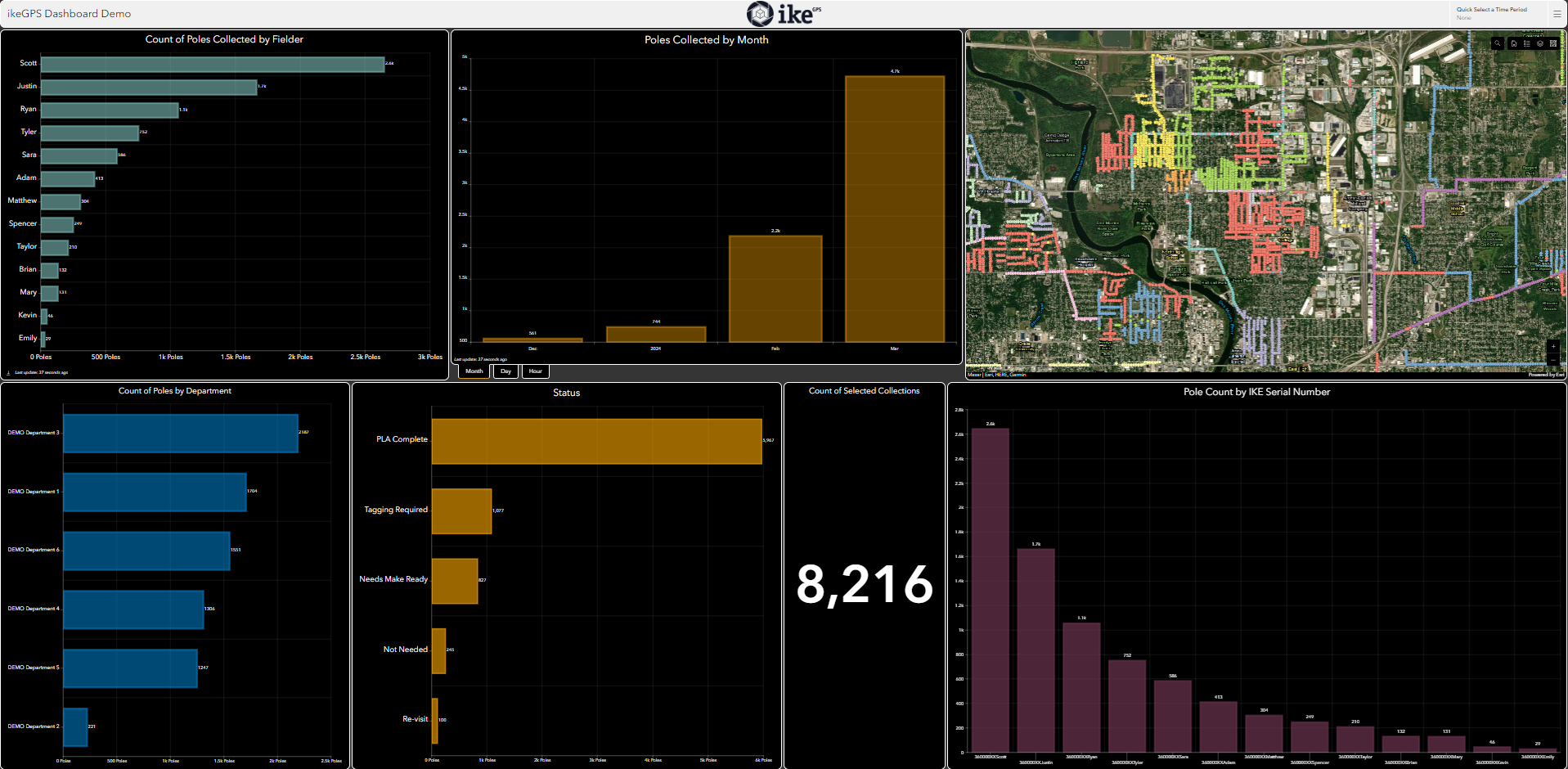
Project managers need visibility, not information that has to be manually gathered and already stale by the time they finish formatting it.
IKE Office Pro’s custom dashboards provide daily project tracking, quality monitoring, and automated client reporting. Modern workflows should not require resources dedicated to manual report compilation. Your subscription includes unlimited hours with our support team to build any custom dashboards you require.
Multi-crew coordination becomes seamless. IKE supports multiple simultaneous collectors on the same job with pole assignment, preventing sync conflicts or sorting chaos.
On-site upload via WiFi hotspots allows back-office teams to flag incomplete poles with notes before field crews leave the area, dramatically reducing recollections.
4. Automated analysis: 30% faster data annotations
PolePilot™ is IKE’s AI-powered pole imagery analysis assistant that’s transforming back-office productivity.
IKE customers report up to 30% time savings in annotation and measurement tasks. PolePilot automatically identifies heights of attached equipment, allowing analysts to quickly approve correct attachment heights and adjust others as needed. Even experienced analysts report the new process is faster than annotating a pole from scratch, allowing them more time to focus on the trickier edge cases that require human judgment.
For firms processing hundreds of poles monthly, this translates to:
- Closing the productivity gap between new and experienced analysts
- Capacity to take on more projects with existing staff
- Faster turnaround times that improve client satisfaction
This level of automation isn’t possible with consumer-grade cameras or smartphones running less sophisticated software. Purpose-built solutions like IKE integrate AI deeply because we optimize the entire stack from image capture to final deliverable.
5. Purpose-built hardware: Field-hardened vs. consumer components
There’s a fundamental difference between purpose-built field equipment and requiring off-the-shelf consumer electronics.
The consumer approach
Some vendors require the separate purchase of digital SLR cameras, cables, SD cards, and smartphone accessories to use their platform. These consumer products are not designed or hardened for daily field conditions. Proprietary height sticks cost $500 each, break regularly, require 4 of 5 calibration points visible (problematic with bushes or fences), and necessitate two-person crews, with someone maneuvering a stick under live wires.
The IKE Device advantage
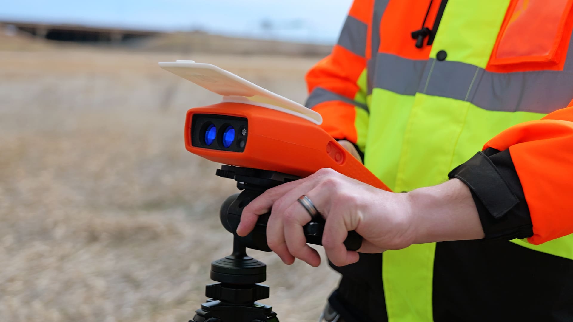
IKE Devices are purpose-built, field-hardened units. Every component is engineered for accuracy, durability, and utility fieldwork demands.
Survey-grade accuracy: Integrated RTK GNSS correction services provide the precise data utility asset owners need for pole loading analysis, make-ready engineering, grid hardening, and resiliency programs. Consumer-grade GPS doesn’t meet this standard, and the alternative to meet this requires field crews to carry a separate RTK unit that costs thousands of dollars.
Compact and reliable: All-in-one design with a single rugged device plus a lightweight carbon fiber tripod (included in the price) instead of a 20-piece retail electronics kit in a bulky camera bag.
Device-as-a-Service: IKE’s device subscription eliminates the need to budget separately for hardware purchases or maintenance. If a device malfunctions, a replacement is shipped out to you the next day, so there is minimal downtime.
Field-to-finish: Your platform choice determines your delivery velocity
Here’s what most organizations miss when evaluating field data collection platforms:
You’re not buying a camera system—you’re choosing the foundation for your entire delivery workflow.
Every hour lost to sync photo failures, GPS misassociation fixes, and recollections delays everything downstream: work prints, joint use tickets, pole loading analysis, and final deliverables. Restrictive exports requiring billable engineering hours trap your data while analysts and clients wait.
IKE accelerates your entire workflow from field to finish. Survey-grade field data flows directly into IKE Office Pro. PolePilot accelerates annotation by 30%. Comprehensive exports and APIs feed your downstream applications like IKE PoleForeman without bottlenecks or billable hours. IKE customers compress their entire delivery timeline while improving quality—winning more work because they deliver faster and capturing higher margins because they’ve eliminated inefficiency at every stage.
Making the right choice
When evaluating solutions, ask questions that reveal true performance:
- Safety: Do personnel need to reach hot sticks into the power space or get dangerously close to environmental hazards like traffic?
- Total Cost: What are all-in costs including labor, engineering fees, equipment replacement, and back-office corrections?
- Data Visibility: Can you get automated dashboards and readouts daily?
- Innovation: Is AI-powered automation driving measurable productivity gains?
- Data Quality: Are you getting survey-grade accuracy for structural design decisions and other downstream work?
Concerned about switching costs?
IKE customers consistently report that time-to-productivity is remarkably short—field crews and back-office analysts typically achieve proficiency in less than a day. The intuitive interface and purpose-built workflow mean the learning curve is minimal. In fact, organizations that have made the switch almost universally say they wish they’d done it sooner, as safety and process improvements quickly offset any transition effort.
Contact our team for a demonstration and TCO analysis based on your specific workflow.
Alex Friedl is Product Owner for IKE Office Pro’s mobile field data collection and data management solutions. With a foundation in archaeological fieldwork, GIS, and spatial analysis, Alex began her career conducting archaeological field surveys before moving into utility line design. During her five years at IKE, she has served in roles across support, quality assurance, business analysis, and product development. Alex oversees product roadmap implementation, feature prioritization, user experience design, and regular release cycles. She leads discovery and requirements-gathering sessions, capturing user insights to translate needs into clear development priorities for engineering teams. Her expertise spans geospatial technologies, survey data collection, product integration, and QA, with a focus on streamlining field-to-office workflows for utility professionals.
The latest from the IKE Wire
Understanding NESC clearance rules for guy wires
Requirements for installing or maintaining down guys and span guys Proper placement a...
Read MoreIKE Office Pro expands field-to-finish process with more integrations to leading pole loading analysis, distribution design, and joint-use software
Latest developments enable best-in-class utility workflows, connecting field data col...
Read MoreIKE product updates: 2025 year in review
Recapping our latest developments in overhead distribution asset management 2025 brou...
Read MoreSubscribe to the IKE Wire
Get the latest insights on data acquisition and structural analysis from the ikeGPS experts.